Storm Samuel puts Canary Islands on alert: hurricane-force winds and rough seas in the coming days
If you stepped outside this morning and felt that damp, irritating air, you weren't imagining it. The Canary Islands are bracing for the arrival of Storm Samuel, and the weather services have already set the wheels in motion. This isn't just another warning; we're talking about a spell of rough weather that's set to keep us on edge through the weekend and, in all likelihood, into the early part of next week.
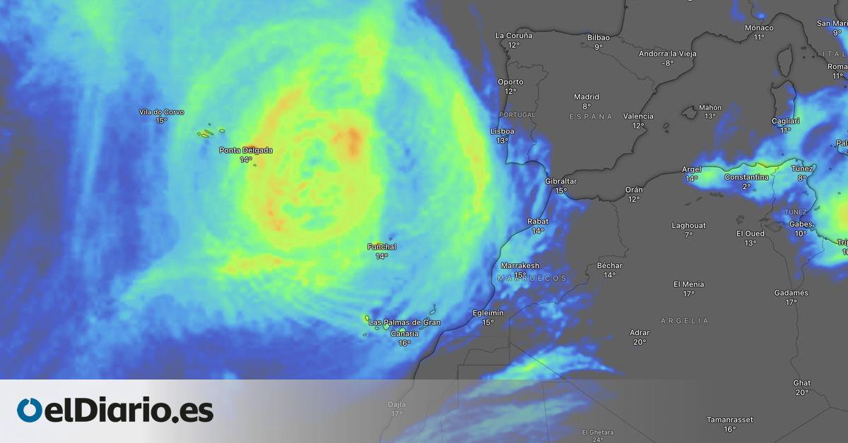
We've seen these systems brew for years, and the one heading our way has an old-fashioned name but the temperament of a rebellious teenager. Samuel is going to let loose with a vengeance. The meteorologists are crystal clear: from this very afternoon, the archipelago will start to feel a general deterioration in conditions. Winds will gust, and on the summits and north-western slopes of the more mountainous islands, they could top 100 kilometres per hour. And here's the kicker: sea conditions are going to turn very nasty, with waves potentially reaching 7 or 8 metres. Not a day for a stroll along the promenade or trying to snap a dramatic selfie – far better to watch it all unfold from home with a nice hot coffee.
Which islands will be worst hit by Samuel?
Speaking as a local who's been through a few storms, I'd say all of them will feel it, but some are going to bear the brunt. According to the models, the islands with the most rugged terrain will suffer the worst of the wind and rain. That means Tenerife, La Palma, Gran Canaria and La Gomera, particularly in the upland and mid-altitude areas. There, rainfall could be locally heavy and persistent, especially between Tuesday and Wednesday. The rest of the archipelago won't escape either: overcast skies, unsettled conditions, and that rolling swell that leaves some reaching for the sea-sickness tablets.
And that's not all. The meteorologists seem to be digging up female names from nowhere. It turns out that hot on Samuel's heels, some are already starting to whisper the name Teresita. Yes, you heard that right. A new disturbance that could form to the west of the islands and further complicate the picture towards the end of next week. For now, it's just a rumour, but in weather terms, when proper names start getting mentioned, it's wise to have your brolly and waterproof coat at the ready.
Advice for the stormy days ahead
No one's here to tell you what to do, but those of us who've seen a fair few branches come down know it pays to follow a bit of sensible advice. Local authorities, working with the meteorologists, have issued the warnings, so take note:
- Avoid walks along coastal areas. The sea can be treacherous, and waves like that show no mercy. If you live near the coast, secure your windows and bring in plant pots or anything that could get blown away.
- Take extreme care on the roads. Gusts of wind can destabilise your vehicle, especially at high altitudes and when exiting tunnels. Best to reduce your speed and increase the gap between you and the car ahead.
- Stay informed. Forecasts can change, and while we'll bring you the latest here, keep an eye on official weather information channels and follow advice from the emergency services.
- Don't underestimate the rain. If you need to go out, wear a waterproof jacket and suitable footwear. Roads can become slippery, and pavements can turn into an ice rink.
The great thing about living in these latitudes is that once the storm passes, the sky clears and that gorgeous light we all love returns. But until then, we've just got to weather the downpour. And with apologies to Samuel, we'll need to keep a close watch on this Teresita character looming on the horizon. You know how it is with weather – you can never let your guard down.
We'll catch up with you once the storm has blown over, with that fresh, clean air and the certainty that, once again, the Canary Islands will stand firm. But for now, wrap up warm, pull the shutters tight, and if you can, just stay put at home. Don't let the wind wipe the smile off your face.