Temperatures Plunge to 10°C Tonight! CWA Reveals the Coldest Moment of This 'Rapid Drop' – Live Look from Three High-Altitude Weather Stations
Heading home from work these past few days, haven't you noticed the wind has changed? That damp chill in the air is back. While walking my dog in the park this afternoon, an older gentleman grumbled, "This wind cuts right through you; the weather's going to turn tonight." And you know what? He was right. This mass of strong, cold continental air has officially arrived, and the worst isn't even here yet—it's coming after dark. Starting this evening, temperatures are going to plummet, and it'll stay freezing all the way into tomorrow morning.
The Main Event Starts After Dark: 'Rapid Temperature Drop' Freezes Until Morning
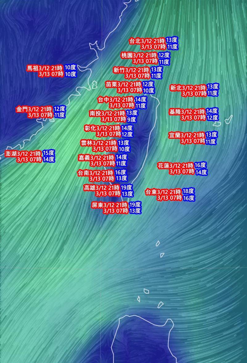
Tonight through early tomorrow morning (March 13th) is the peak period for this cold front. Think of it like boiling a pot for hot pot: you don't feel much right after you turn on the heat, but once it starts rolling, that's when the real heat hits—except this time, it's cold. The daytime weather might seem stable, but as soon as the sun goes down, low temperatures in areas north of central Taiwan and in Yilan will drop to 11 or 12°C. In open areas or flatlands near mountainous regions, we could even see extreme lows around 10°C. While southern Taiwan won't feel it as intensely as the north, overnight lows will still hit 14 or 15°C. The temperature swing is significant, so don't think you can just stroll around in a t-shirt if you're down in Kaohsiung or Tainan.
Live from the High-Altitude Stations: Current Conditions at Yushan, Sun Moon Lake, and Taichung
Whenever a cold front like this hits, one of the best things to do is check the live feeds and data from our high-mountain stations. They're the real front lines of winter. Although this front isn't carrying as much moisture as the last one, so heavy snow is less likely, these Central Weather Administration (CWA) outposts are already showing their true winter colors.
- CWA Yushan Weather Station: This is Taiwan's benchmark for extreme cold. While there are no reports of significant snowfall yet, temperatures at the station have been hovering around the freezing mark (0°C). Add in the wind speed, and the wind chill makes it feel well below zero. The crew working up here has to bundle up fully just to step outside – this is no joke.
- CWA Sun Moon Lake Weather Station: Evenings get seriously chilly at Sun Moon Lake. Tourists might enjoy tea by the lake during the day, but after dark, the temperature drops sharply. That lake moisture combined with the cold air creates a damp chill that seeps right into your bones. Data from this station is crucial for tracking temperature drops in the central mountain region. For photographers hoping to capture morning mist or frost, keep an eye on the real-time updates from this station.
- CWA Taichung Weather Station: Even though Taichung is an urban area, its geographic location makes it prone to strong radiational cooling. Days might be sunny and feel pleasant, but the temperature plummets rapidly once the sun goes down. Data from the Taichung station perfectly captures this dramatic swing between warm days and cold nights. Early tomorrow morning, lows here could very well dip below 11°C.
And of course, we can't overlook observations from the flatlands, like the CWA Kaohsiung Weather Station. People in Kaohsiung might think, "It's not that dramatic," but the overnight low will actually be quite noticeable. Especially in open, coastal areas, that wind can make the cold downright uncomfortable, even giving you a headache. Recent data from the Kaohsiung station shows temperature swings often exceeding 10°C between day and night. Seriously, don't be fooled.
Warming Up Friday Daytime? Don't Put Away Your Winter Coat Just Yet.
Everyone's asking how long this cold snap will last. The strongest part of this cold air mass will be early Thursday morning (March 13th), with temperatures rebounding slightly during the day after that. But note the key word: slightly. While Friday might see some sun, clouds and moisture moving in from southern China will increase humidity overnight and into the weekend. This will bring back damp, cooler conditions to the north and east, which might feel even chillier than what we're experiencing now.
Ultimately, this is classic spring weather: unpredictable swings between warm and cold. Until this cold air mass truly weakens and temperatures stabilize, keep that heavy jacket handy. Layering up is the safest bet. And for those heading out to work or school tomorrow morning, be sure to brace yourself for that sudden deep freeze. Dress warmly, or you'll be questioning your life choices within the first minute of your commute.
One final reminder: For the most accurate and up-to-date weather info and temperature changes, always check the official Central Weather Administration (CWA) website or app. Get your data from the most reliable source—don't just rely on random weather pages you find online. It's going to get cold tonight. Make sure you have a good blanket. That's all for now.