Evening temperature to plunge to 10°C! CWA reveals the coldest moment of this rapid cooldown – Latest from three mountain weather stations
Have you noticed on your way home from work these past few days that the wind has changed, bringing back that damp, chilly feeling? I was walking my dog in the park this afternoon when an old-timer muttered, "This wind cuts right through you; the weather's set to change tonight." And he was spot on. This continental cold air mass, carrying a punch of frigid air, has officially arrived in Taiwan. The worst isn't now, though—it's after dark. From this evening, temperatures will plummet like a rollercoaster, with the cold lasting through until tomorrow morning.
The main event kicks in after dark: 'Rapid cooldown' to continue until tomorrow morning
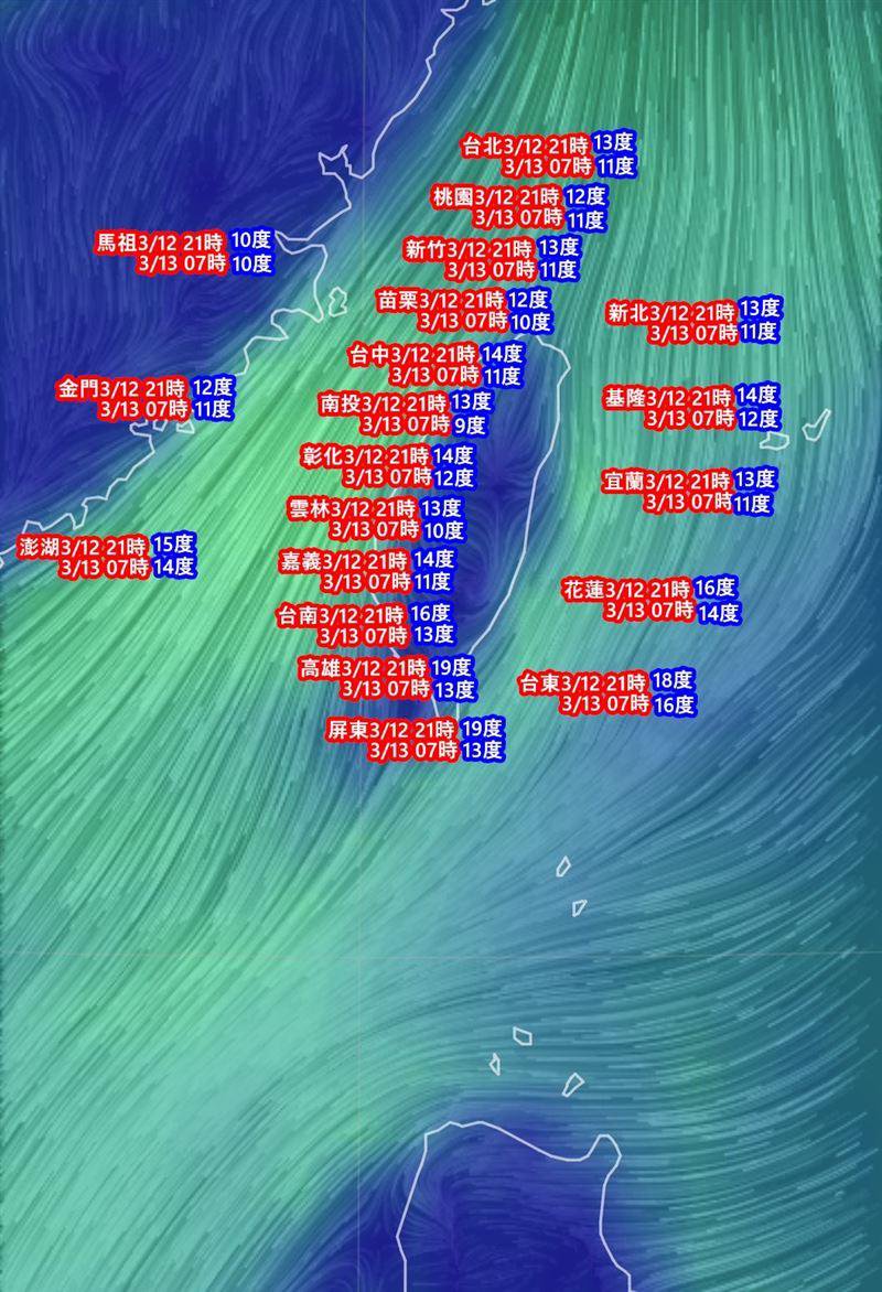
The 'peak' of this cold air will be from tonight until tomorrow (March 13th) morning. Think of it like heating a pot for hotpot—you don't feel much when you first turn on the heat, but once it starts boiling, the real warmth hits. Except this time, it's the cold hitting. Daytime weather might be relatively stable, but once the sun sets, temperatures in areas north of central Taiwan and in Yilan will drop sharply to 11-12°C. In open areas or flatlands near hilly regions, we could even see extreme lows around 10°C. While southern Taiwan won't feel it as intensely as the north, temperatures will still fall to 14-15°C after dark—a significant drop. Don't think you can just wander around in a t-shirt just because you're down in Tainan or Kaohsiung.
On the ground at mountain stations: Current conditions at Yushan, Sun Moon Lake, and Taichung
Whenever a cold air mass like this hits, my first stop is the live feeds and observation data from the mountain stations – they're the true front line of winter. Although this air mass isn't carrying as much moisture, so conditions for high-mountain snowfall aren't as good as the last one, these Central Weather Administration (CWA) outposts are already looking very wintry.
- CWA Yushan Weather Station: This is Taiwan's 'cold pole' indicator. While there are no reports of widespread snow accumulation yet, temperatures at the station have been hovering around freezing point (0°C) for a while. Add in the wind speed, and the wind chill makes it feel well below zero. Staff working at the station have to be fully geared up just to step outside – it's a seriously biting cold.
- CWA Sun Moon Lake Weather Station: Evenings turn decidedly chilly here too. Tourists might still be enjoying tea by the lake during the day, but after sunset, the temperature plummets. The moisture from the lake combined with the cold air creates a damp chill that seeps right into your bones. Observation data from this station is crucial for tracking temperature changes in the central mountain region. Photography enthusiasts hoping to capture morning mist or frost scenes should keep an eye on the real-time updates from this station.
- CWA Taichung Weather Station (under the Ministry of Transportation and Communications): Even though Taichung is an urban area, its geographical location makes it particularly prone to radiative cooling. You might see some sunshine during the day and think "this isn't so bad," but once the sun goes down, the temperature drops incredibly fast. Data from Taichung station perfectly illustrates this dramatic temperature swing – warm days, frigid nights. There's a real chance the low tomorrow morning could dip below 11°C.
Of course, we can't overlook observations from the flatlands, specifically the CWA Kaohsiung Weather Station. While locals in Kaohsiung might think "it's not that dramatic," the actual low temperatures after dark will be noticeable. Especially in open, coastal areas where the wind picks up – that kind of cold can give you a headache. Recent observation data from Kaohsiung station shows daily temperature swings often exceeding 10°C, so don't be tempted to underestimate it.
Warming up Friday daytime? Hold off on packing away the winter coats
Many are asking how long this cold spell will last. The peak intensity of this cold air will be on Thursday morning (March 13th), after which daytime temperatures will climb back up slightly. But note, it's only 'slightly'. Although there might be some sunshine on Friday, moisture will increase from Friday night into the weekend as a cloud band moves in from southern China. This will bring more damp, cool weather to the north and east, which could feel even less comfortable than now.
Ultimately, this is the classic "late spring chill". Until the cold air mass weakens and temperatures stabilise, it's best to keep that thick coat handy and stick to layering up. This is especially true for those heading out to work or school tomorrow morning – make sure you brace yourselves for that sudden freeze. Wrap up warm, or you might find yourself questioning life choices within the first minute of stepping outside.
One final reminder: for the most accurate and up-to-date weather information and temperature changes, keep checking the official Central Weather Administration (CWA) website or App. It's the most reliable source – better than some random weather pages with questionable accuracy. It's going to be cold, so make sure you have a good blanket tonight. That's all from me.