Weather forecast: Autumn 2026 starts with heat, and the first real cold snap already has a date to arrive
If you were hoping for that lovely crisp chill right in the first week of autumn, you'll have to hold your horses a little longer. Autumn 2026 officially kicked off this Friday, 20 March, but the weather forecast for the coming days is for plenty of heat and a scenario that's a far cry from what we used to see in the past.
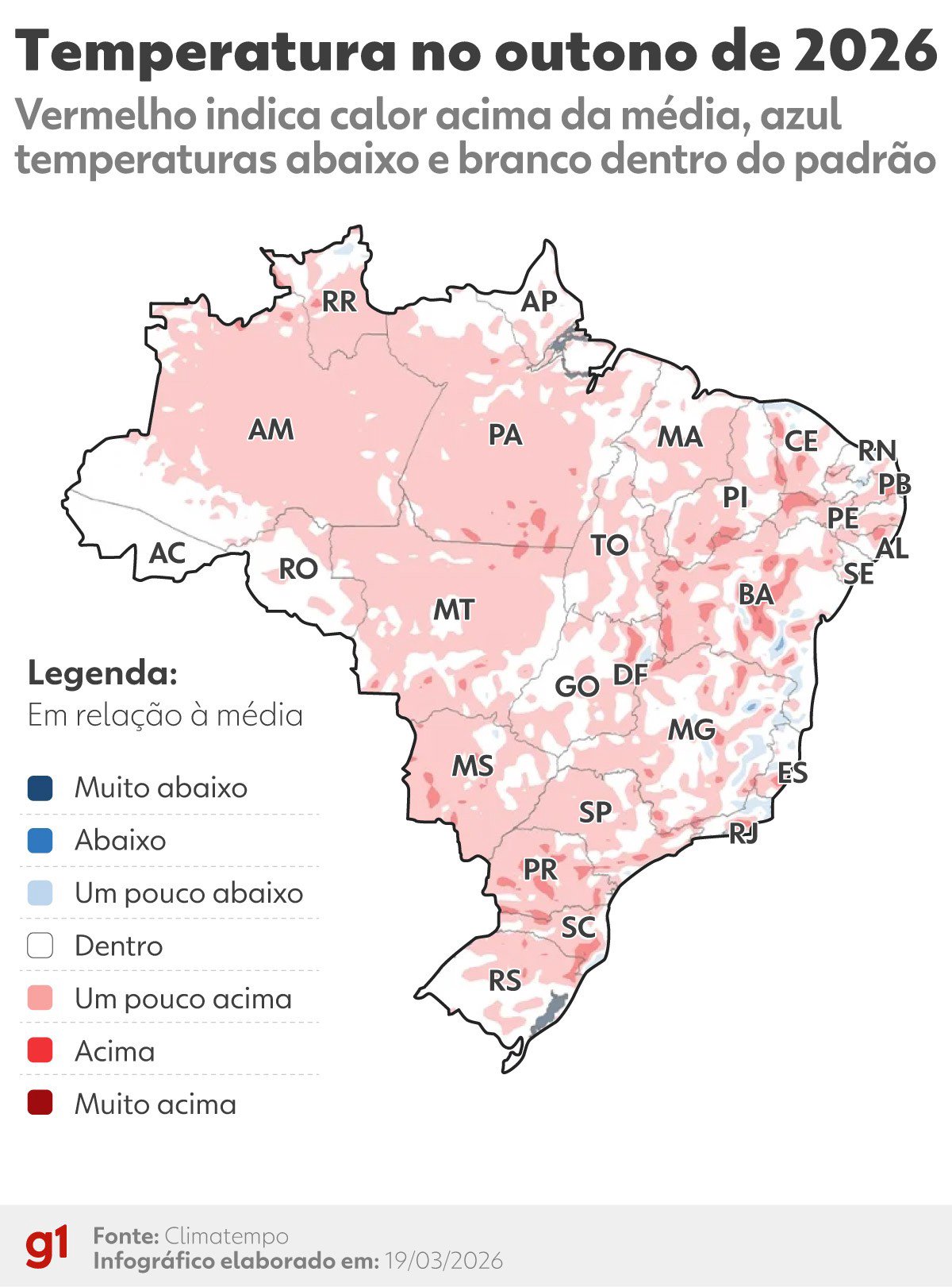
At least, that's what the latest maps are showing. The season of falling leaves is set to arrive with above-average temperatures across most of the country. Remember that famous 'friagem' (cold snap) that was already making an appearance at the end of summer? Well, it's taken a break. For those living in the Southeast and Central-West, for instance, you'll still be facing days where the thermometer easily tops 30°C, as if summer is stubbornly refusing to leave.
Persistent heat and patchy rain
What stands out about this seasonal shift is the irregularity. The weather and climate forecast indicates that rainfall will be poorly distributed. While the South and parts of São Paulo might still see more consistent rain in the first few weeks, the interior of the Northeast and northern Minas Gerais will continue to see water shortages. And that's a concern, because it's been a while since we've seen a 'normal' rainfall pattern like we used to have.
To give you an idea, running the forecast models on the platforms we use to track wind and pressure, the scenarios show a persistent atmospheric block. In practice, this means a mass of hot air remains stationary, preventing those cold fronts that usually bring true autumn weather from arriving straight away.
And the cold, when will it actually arrive?
The big question on everyone's lips: where's the cold? Well, I've been keeping an eye on the forecast models and the date is already on the radar. The first intense cold snap of autumn, the kind that makes you dig the coat out of the wardrobe and even wrap your hands around a hot coffee in the late afternoon, is forecast to arrive in the first week of April. More specifically, between the 6th and 9th.
It's during this period that a polar air mass is expected to send temperatures plummeting in the South of the country and cause a significant thermal shock in the Southeast. But don't expect a gradual change. The trend is for us to go from sweltering heat of almost 35°C straight down to 15°C in a matter of hours. This kind of abrupt transition is typical of Brazilian autumn, but this year it promises to be more intense.
- South (RS, SC, PR): Be extra vigilant! The turn of the month already starts with a drop in temperature. Get the blankets and heavier coats ready for the first week of April. Frost could appear in the highland areas.
- Southeast (SP, RJ, MG, ES): The forecast is for heat to dominate the last days of March. The cold is only expected to arrive in earnest around 7 or 8 April, with that icy wind that cuts right through you.
- Central-West and Northeast: The change will be felt less intensely, but nights will become milder, especially in higher-altitude areas like Chapada Diamantina and the region around Brasília.
If there's one thing I've learned following the climate - weather forecast all these years, it's that autumn in Brazil has become a box of surprises. Nothing is the same as it was ten years ago. We need to keep an eye on constant updates, because this back-and-forth of hot and cold air masses ends up catching everyone off guard.
So, the advice is: enjoy this last weekend of March with that lingering heat, because soon enough, that intense cold will be knocking on the door. And when it knocks, it won't be just to say hello. It'll be here to stay. Love weather? For now, it's only love for the blanket, because outside, it's going to be that kind of weather.