Why MetService NZ is the Unsung Hero of Our Economy and Safety
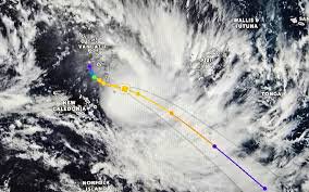
Right now, as I type this, a tropical low we've been watching for days has officially intensified into Cyclone Urmil over the Coral Sea. It's brushing past Vanuatu, and while it's not a direct hit for us, every farmer in Northland, every skipper out of the Bay of Islands, and every logistics manager at Fonterra is refreshing one site: MetService. We Kiwis have a quiet, unspoken relationship with our national weather authority—MetService NZ. We check it before we hang the washing out, sure. But its real value, the kind that moves markets and saves lives, runs far deeper than your average phone app.
The Pacific Watchtower
To understand why MetService is indispensable, you have to look north. When a disturbance forms near Fiji or Vanuatu, our Metservice team—or Te Ratonga Tirorangi as it's known in te reo—kicks into high gear. I've spent years watching these guys work. They're not just forecasting rain; they're modeling storm surges that could wipe out coastal villages in the Pacific, and tracking swell that will pound our own west coast three days later. The red alert issued for Vanuatu's province isn't just a headline; it's the result of a data pipeline that starts with our own analysts and satellites. This isn't about being paranoid; it's about being prepared. And in my book, that vigilance is a commercial asset New Zealand often takes for granted.
Where the Rubber Hits the Road: Rural and Commercial
Let's talk money. The backbone of our export economy—dairy, kiwifruit, wine—is completely exposed to the whims of the sky. This is where MetService Rural Weather becomes the most powerful tool a farmer owns. I was chatting with a mate who runs sheep in the Hawke's Bay last week. He doesn't care about the urban forecast. He needs to know the precise wind speed at 200 meters to avoid spraying off-target, and the soil moisture deficit to plan his irrigation roster. That level of granularity isn't a luxury; it's the difference between a profitable season and a write-off.
Beyond the farm gate, the commercial applications are staggering. Insurers use MetService data to price risk. Construction firms schedule pours around the windows it predicts. The entire domestic aviation sector—Air New Zealand, the freight operators—they're all synced to the same source. When a tropical depression near Fiji gains strength and becomes Cyclone Urmil, as we saw this week, the ripple effects hit every boardroom in the country. Supply chains are rerouted, fuel is hedged, and contingency plans are dusted off. The value locked inside those forecast models is incalculable.
The Unseen Layer of Resilience
What impresses me most, after two decades in this game, is the cultural shift. We've moved from treating weather as small talk to treating it as a strategic input. The old days of just hoping for a fine weekend are gone. Now, a trucking company dispatcher can look at a 10-day outlook and decide to pull a job forward to avoid a front coming through the Kaimais. A regional council can pre-position pumps based on a Metservice heavy rain watch. This is the quiet infrastructure of a resilient country.
Think about the critical sectors that live and die by this intel:
- Primary Industries: Frost protection, harvest timing, and stock management all hinge on hyper-local rural forecasts.
- Transport & Logistics: From Ports of Auckland to remote airstrips, operations are calibrated around wind and visibility.
- Energy: Grid operators predict load based on temperature, while hydro lakes are managed around incoming rain.
- Tourism: Every helicopter operator in Franz Josef and every skipper in the Bay of Islands checks the marine forecast before taking clients out.
A Commercial Future Written in the Clouds
Looking ahead, I see MetService evolving from a public service into a high-value data powerhouse. The demand for tailored, sector-specific insights is exploding. Imagine AI models trained on decades of its archives, giving a vineyard a 20-year projection of bud burst dates, or telling an insurance actuary the exact probability of a 1-in-100-year flood in a specific catchment. That's the next frontier. The crown entity we casually check on our phones is sitting on a goldmine of proprietary information.
As Cyclone Urmil continues its path and we watch its progress through the Pacific, let's remember that the map we're staring at—the one with the colored cones and the tracking lines—is a piece of world-class Kiwi ingenuity. It's not just weather. It's business intelligence. It's safety. And it's the reason, no matter what the sky throws at us, we're always a few steps ahead.