Severe Thunderstorms and Tornadoes Hit the Plains: What You Need to Know
If you're anywhere from north Texas up through Missouri, you can already feel it in the air—that heavy, charged feeling that tells you the atmosphere is primed for action. And it's not just a gut feeling. We are right in the middle of a multi-day severe thunderstorms outbreak that has everyone from storm chasers to local police on high alert. Let’s break down what’s happening, hour by hour, because this is one of those days where you really need to stay weather-savvy.
Today’s Threat: The Dryline Sparks Up
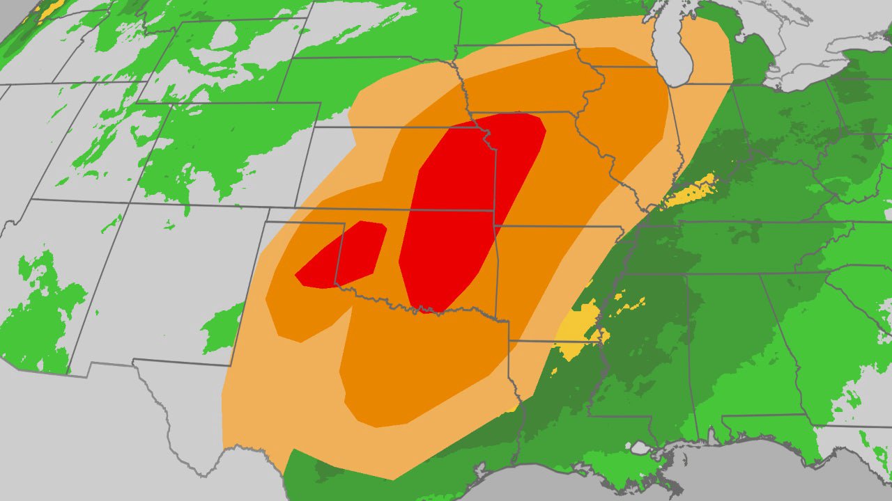
All eyes are on the dryline this afternoon and evening. For those not in the know, that’s the boundary between dry desert air and the moist, unstable air surging up from the Gulf. Think of it as the trigger. Right now, that trigger is stretched across western Texas, through western and central Oklahoma, and into southwestern Kansas. By late afternoon, word from storm chasers on the ground is that we expect it to ignite.
These won't be your run-of-the-mill thunderstorms. We're talking supercells—the kind of rotating beasts that can produce everything. The official word from the Storm Prediction Center has pegged a Level 3 out of 5 risk right over this region, and for good reason. The ingredients are there: intense wind shear and instability. If you're in places like Oklahoma City by this evening, you need to have a plan. This isn't just a "watch the sky from the porch" kind of situation. The potential is there for strong tornadoes, the kind rated EF2 or higher, to touch down. And let's not even start on the hail. We're talking about stones larger than golf balls in some of these cells—that'll shred a roof and total a car in minutes.
Friday’s Second Round: From the Panhandle to the Great Lakes
Here's the thing about set-ups like this: they have multiple acts. After today's chaos, the atmosphere is going to recharge and do it all over again on Friday. The target zone shifts and expands. We're looking at a sprawling area from the Lone Star State all the way up to the upper Midwest.
If you're in northern Texas, western Missouri, or even as far north as southern Minnesota and the Chicago suburbs, Friday afternoon and evening are your prime time. The models are hinting at another round of intense supercells. We could see hail and damaging winds sweep right through the southern Great Lakes region. It’s the kind of forecast that makes you want to double-check your emergency kit and make sure your phone alerts are switched on.
Beyond the Forecast: Understanding the Beast
Whenever I see a pattern like this, I find myself going back to the basics—the kind of stuff we learn from the great textbooks. You can see the concepts from Meteorology Today: An Introduction to Weather, Climate, and the Environment playing out in real-time, like the battle between different air masses and the role of upper-level energy. It's one thing to read about a "cap" in The Atmosphere: An Introduction to Meteorology, but it’s another to watch it break and see the storms explode on radar. For anyone really wanting to geek out on the details—the lapse rates, the helicity—picking up a copy of Exercises for Weather and Climate is a great way to go from spectator to someone who actually understands the "why".
But look, you don't need a degree to respect what's coming. Sometimes you just need to know what you're looking at. Grab a copy of the Peterson Field Guide to Weather. It’s one of the best books out there for identifying cloud formations and understanding what they mean for you on the ground. And for the folks who are the real heroes in these situations—the SKYWARN spotters—their bible is the Weather Spotter's Field Guide. These are the men and women who provide ground-truth reports to the National Weather Service, and they are absolutely invaluable during outbreaks like this.
The Bottom Line: Stay Ready
Here’s what I need you to take away from this:
- Today (Thursday): The highest risk is western Texas, Oklahoma, and southwestern Kansas this afternoon and evening. Strong tornadoes and giant hail are the main threats.
- Tonight: The threat could push toward the Oklahoma City metro area.
- Friday: A major outbreak is possible from Texas to the upper Midwest, including Missouri, Iowa, and even southern Minnesota and the Chicago area.
- Stay Informed: This is not a drill. Have multiple ways to get warnings. Know your safe place. And if you don't have a plan, make one now.
This is a dynamic, dangerous situation. The atmosphere is a powerful machine, and for the next 48 hours, it’s firing on all cylinders. Let's make sure everyone gets through this safely.